Karst Hydrology

Understand the limestone formations, underground aquifers, and seasonal river surges of central Sardinia.

Photo by vasile23 / Openverse

Foundations of the Supramonte

The geological structure of the Lanaitho Valley is a classic example of Mediterranean karst topography. The valley is located in the Supramonte of Oliena, a massive mountain plateau composed of Mesozoic limestone. This limestone was deposited in ancient shallow seas millions of years ago. Over geologic eras, tectonic movements lifted these limestone beds. This movement exposed them to rain and wind. Rainwater absorbs carbon dioxide from the air and soil, which forms a weak carbonic acid. This acid dissolves the calcium carbonate in the limestone. This dissolution creates fissures, sinkholes, and caves.

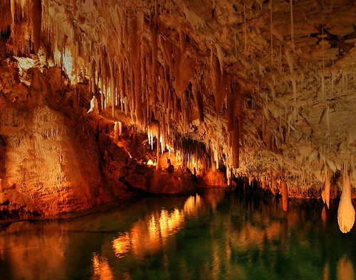
Grotta Corbeddu is one of many caves formed by this process of dissolution. The cave has wide galleries and chambers that were carved out by ancient underground water flows. Over time, the local water table dropped. This drop left these upper chambers dry. Dissolved minerals continued to drip from the cave ceiling. These minerals formed stalactites and stalagmites. These mineral formations grow slowly. They add only a few millimeters each century. The sediment layers on the cave floor also accumulated over thousands of years. These layers preserved fossils of extinct animals and tools from early human groups.

The rock layers inside the cave show distinct geological periods. Speleologists study Speleothem layers to reconstruct the climate history of Sardinia. The transition from wet glacial periods to dry modern climates is recorded in the chemistry of the mineral deposits. This geological record brings context for the archaeological findings. It shows how early humans adapted to changing environmental conditions.

Subterranean Aquifers and Interconnected Caves

The caves of the Lanaitho Valley are not isolated structures. They form a vast, interconnected network of underground channels that carry water across the Supramonte.

Grotta di Sa Ohe ("The Voice")

This cavern has a massive entrance. This opening functions as an overflow point for the underground river system. During heavy autumn and winter rains, the rising waters inside the karst channels compress the air. This compression produces a loud rumbling sound that echoes through the valley. This sound gives the cave its name and works as a natural warning of rising waters.

Grotta di Su Bentu ("The Wind")

Located near Sa Ohe, this cave has kilometers of surveyed passages and deep underground lakes. The cave is famous for its strong air currents. These currents are caused by the temperature differences between the exterior air and the constant 15°C (60°F) climate of the deep karst interior.

Su Gologone Spring

This karst spring is the primary outlet for the entire Lanaitho water network. The water flows from a deep limestone ravine over 100 meters down. During winter, the spring discharges thousands of liters of water per second. This spring is the major source of drinking water for the Oliena and Dorgali municipalities.

Seasonal Hydrological Cycles & Safety

The water flow in the valley is highly seasonal. November is the wettest month of the year, with an average of 3.55 inches of rainfall. This heavy rain filters through the limestone plateau. The water fills the underground channels. The rising water levels can cause sudden discharges from the mouth of Sa Ohe Cave. This surge floods the nearby roads and trails.

In contrast, the surface rivers dry up completely during the dry summer months of July and August. The valley floor becomes hot and dusty. Yet, the deep caves maintain their constant 15°C (60°F) temperature. This climate brings relief from the heat. This cool air is a result of the thermal insulation of the thick limestone layers.

Understanding these seasonal cycles is essential for safe exploration. Visitors must check the weather forecasts and respect the safety warnings issued by the local cooperative. If heavy rains are predicted, you must avoid the low-lying trails near Sa Ohe Cave.

Hydrology Quick Facts

Rock Type: Mesozoic Limestone
Cave Temp: 15°C (60°F) constant year-round
Wettest Month: November (3.55 inches average)
Primary Spring: Su Gologone karst spring
Connected Sights: Sa Ohe, Su Bentu, Corbeddu

Geology FAQ

Does the cave system connect with other caverns?

Yes. Grotta Corbeddu is part of a larger karst network that connects underground with the adjacent caverns of Sa Ohe and Su Bentu. This system drains water from the Supramonte plateau.

Does heavy rainfall affect the valley aquifers?

Yes. Heavy autumn and winter rain filters through the limestone. This water reactivates the underground rivers. This process can cause sudden river surges and water discharges from Sa Ohe Cave.

Is Su Gologone Spring connected to these caves?

Yes. The Su Gologone karst spring is the primary outlet for the vast subterranean network of the Lanaitho Valley. It drains water from the limestone fissures over 100 meters deep.

Are there caves in Sardinia?

Yes. Sardinia has extensive karst limestone geology, which results in hundreds of caves. Famous subterranean systems include Grotta di Nettuno, Grotta di Ispinigoli, and Grotta Corbeddu in the Supramonte.

Where is Neptune Cave in Sardinia?

Neptune's Cave (Grotta di Nettuno) is located on the northwest coast of the island, near Alghero, on the rocky cliffs of Capo Caccia. Unlike the inland Corbeddu Cave, it is a marine cave accessible by boat or steps.